E-Mail to Dennis Crider re:
Exhibit 22c
From: Bob Donaldson
Sent: Tuesday, February 22, 2000 10:32 PM
To: criderd@ntsb.gov <mailto:criderd@ntsb.gov>
Cc: Paul Marcone; cmdrdonaldson@yahoo.com
Subject: TWA Flight 800,
Exhibit 22c
Dennis,
I have been reviewing Exhibit 22c and I have some questions.
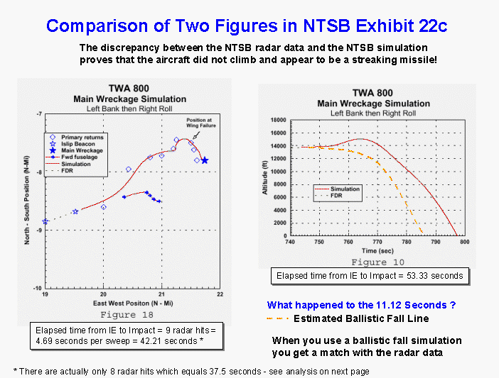
1. There seems to be a discrepancy between
Figure 18 and Figure 10. Figure 10 shows that the aircraft was in
the air for 53.3 seconds, yet Figure 18 shows the aircraft was only visible
on radar for 8 sweeps (the graph shows 9, but its wrong). That's
only 37.7 seconds. The difference is 15.8 seconds or nearly 4 more
radar sweeps. Since the radar was picking up small boats in the area,
the aircraft should have been visible to the radar all the way to impact.
Therefore, it appears that the radar data does not support the Zoom Climb
scenario's proposed by the CIA and NTSB.
The two graphs I referenced can be found here:
http://twa800.com/images/exhibit22c_1.gif
Q. Did you find anything in the radar data that supports the Zoom Climb
scenario?
2. I did not find a time vs. altitude
graph which plots a ballistic fall. It would seem that this scenario
would be far more likely than the zoom climb.
Q. Why didn't you calculate or simulate a ballistic trajectory for the
main aircraft wreckage when you calculated one for dozens of other aircraft
parts?
2. When I plotted a ballistic trajectory
on Figure 10 it shows the aircraft impacting the water after radar sweep
8. Therefore, the radar supports this scenario more than the zoom
climb.
Q. Wouldn't you agree that a ballistic fall is at least as reasonable
a scenario as the zoom climb and more probable based on the radar data?
3. Figure 18 shows 9 radar hits with a
trend line going through them. When I plotted the raw data released
recently at the NTSB web site, there are only 8 hits on the Islip radar.
There were two hits on sweep 6 and it appears someone mistook this as an
additional radar sweep. In the following graphic I plotted the raw
radar data against figure 18. It shows a discrepancy between your
plot and the raw radar data.
Q. Why is there a discrepancy in the plots?
Q. Do you agree that there were only 8 radar hits?
4. When I plotted the ballistic fall against
the zoom climb scenario from the CIA and the NTSB it shows that radar contact
would have been lost at 15,000 ft in the CIA scenario, or at 8,000
ft with the NTSB zoom climb scenario. The ballistic fall scenario
shows it impacting the water after the last radar sweep. Following
is a link for the graphic showing the above.
http://twa800.com/images/fall.pdf
Q. How do you account for the loss of radar contact at 15,000 ft. or
8,000 ft. in the two zoom climb scenarios?
Q. Wouldn't you agree that the ballistic fall scenario fits the radar
data better than the zoom climb scenario?
5. It appears from all the evidence,
including the eyewitnesses and the radar data, that the aircraft did not
perform a zoom climb, but fell ballistically.
Q. If the plane fell after the nose came off, what did the 96 eyewitnesses
see, who saw a streak of light rise from the surface and impact the aircraft?
Thank you for your time. I'm sure you are very busy, but since there
is, as yet, no plausible explanation for the loss of Flight 800, I expect
you are as anxious as everyone to "turn over every
rock" and explore all possibilities.
Regards,
Bob Donaldson
(Cmdr Donaldson's brother)
http://twa800.com